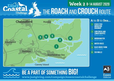
It’s Week 2 of the Essex Coastal Challenge and we’re exploring the tidal rivers Roach and Crouch – and some key species that have made these waters their home.
Welcome to the story of Essex’s beautiful coast. We left the industrial Thames Estuary behind us last week and now we meander through a maze of marshy creeks and Saxon settlements, taking in stunning rural views steeped in history and ending at the Dengie Peninsula - possibly the most remote corner of our vast county…
We begin just north of Gunners Park, where last week’s adventure ended; now we’re travelling inland, along the south bank of the River Roach. Take in the rainbow colours of the marshes in the early morning sunshine and perhaps see a near-threatened avocet, extinct in the UK during the 19th century, now harassing a large passing marsh harrier that arrived on our shores in April for the summer. Fifty years ago, only one nesting female marsh harrier could be found in the UK due to decades of persecution and habitat loss; now these impressive birds of prey number nearly 400 pairs. Across the river, spot the distant Canewdon church – with no cliffs or headland on the horizon, it’s our landmark across this flat watery landscape for most of the week. To your left, catch views towards the tall buildings of Southend. The occasional roar of an aeroplane taking off or landing at nearby Southend airport will break the stillness. Behind you in the marshes lies Potton Island, inhabited since at least the Neolithic era.
The Essex Fish Migration Roadmap [1]
A distinguishing feature of the Essex coastline is its rivers and estuaries, and this week’s coastal section is no different. The remains of a dock whose ship once carried famous naturalist Charles Darwin on his expedition to the Galapagos Islands is submerged in the mud here. As the blue veins that connect the land to the sea, it’s unsurprising that these rivers are steeped in smuggling history... But there are no smugglers or pirates on the river this week – spot noisy orange-beaked oystercatchers instead, facing into the breeze. Essex has arguably the longest coastline of any English county and what we do to our rivers directly impacts the coast. But these precious blue ribbons have become fractured by centuries of human intervention: in Essex there are 304 barriers to fish movement on our main rivers! Construction of weirs, flood barriers, mill gates and other structures have decimated breeding cycles of many species of fish. Upstream pollution, too, causes damage to river biodiversity with no hope of recovery for wildlife habitats further downstream. Across the greater Thames region only 19% of our rivers were open for upstream migration of eels and 24% to other fish.
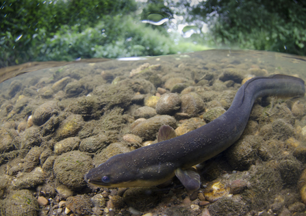
The Essex Fish Migration Roadmap is a county wide initiative that shows where fish are able to travel up and down our rivers and how these link to the sea. It identifies physical improvements to return our rivers to a more natural state and kickstart a species recovery across Essex and beyond. Kingfishers will feed on minnows and metallic-blue damselflies and dragonflies will glint in the August sunshine as they hunt along reedy margins of nutrient-rich riverbanks – because when fish thrive, other species thrive too. Thanks to conservation work, otters (extinct in our rivers in 1986) are now present and feeding on fish such as perch, roach and even stickleback.
The whole of Essex has now been mapped with all the ‘roadblocks’ identified on an interactive map and we hope to have paper roadmaps available soon. But now, with help from landowners, we need to solve them!
Lion Creek and Lower Raypits nature reserve [2]
We wave goodbye to the Roach where it feeds into the mouth of the River Crouch. Find Lion Creek and Lower Raypits nature reserve: although dwarfed by the large neighboring nature reserves at Wallasea and Blue House Farm, it’s still an important piece of the wider Crouch Estuary landscape, providing refuge for species such as dark-bellied brent geese, water voles and bumblebees. August will see the lagoon visited by waders on passage; and soon black-tailed godwits, classified ‘Red’ in the UK as a bird of conservation concern, will start to arrive to these coastal estuaries for the winter. These faithful little birds stay with the same mate every year for 25 years: they sweetly arrive at their breeding grounds within three days of each other, every year, to mate and raise their chicks together.
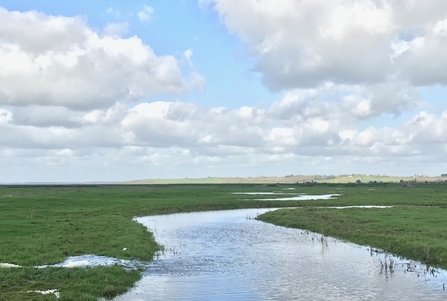
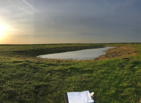
Our groundbreaking habitat restoration project at Lion Creek and Lower Raypits retains winter rainfall to ensure sufficient water to allow important wetland birds like the black-tailed godwit to breed – no mean feat, given that the area has an average annual rainfall lower than Jerusalem! We constantly monitor wet grassland conditions so that it’s optimum for its special wildlife.
Views across the River Crouch and to the southern shores of the Dengie Peninsula are occasionally broken by passing watercraft. Spot North Fambridge’s pretty sailing boats across the river. While the time away by the sea wall, heading inland again along the southern riverbank, and look for two of the UK’s rarest bumblebees – the brown-banded carder bee and the rapidly declining shrill carder bee.
Woodham Fenn [3]
Pass through Canewdon, steeped in folklore and witchcraft legend, and its landmark church with views across to Southend and the paths we trod last week by the Thames Estuary further away; and, in the very far distance,
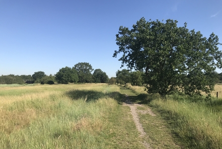
Kent is on the horizon. Follow old tracks once used by smugglers round to the northern side of the Crouch and Woodham Fenn, a nature reserve whose saltmarsh is a designated Site of Special Scientific Interest (SSSI), Ramsar Wetland of International Importance and part of the Essex Estuaries Special Area of Conservation under the Habitats Directive. It’s a transition zone from grassland to saltmarsh: this is a very rare feature on the Essex coast and its tidal channels provide perfect opportunities for studying changes in coastal wildlife.
Water voles [4]
This ancient site sits beside tidal Fenn Creek (Iron Age skulls have been found in the bed of Fenn Creek). Continue along the sea wall and divert your gaze from the creek to the water filled ditches and dykes (common features along our coastline) and you may be lucky enough to see - or spot signs of - water voles. When swimming these critters look like a little brown hairbrush with an outboard motor attached; and can chop down and devour a huge reed in a single sitting, leaving a nibbled 'lawn' of reeds around the entrance to its riverbank burrow.
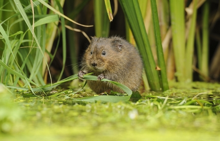
Water voles were once a common sight on our rivers but they are our most endangered river mammal. Already at a historic low in 2006 and completely extinct across 83% of Essex, over the next 10 years distribution rapidly and catastrophically declined by a further 30%. But Essex is one of the strongholds for water voles in the UK due to the coastal ditch and dyke systems in our grazing marshes, so we have a brilliant conservation opportunity. Help us by photographing and recording any water vole sightings – or even volunteer to take part in one of our water vole surveys.
Blue House Farm [5]
The gradually widening river Crouch leads you to another Site of Special Scientific Interest: Blue House Farm. Stroll around the 284 hectare Farm - take in views across the glorious estuary; keep an eye out for patrolling dragonflies, including the scarce emperor dragonfly; listen for the ‘plop’ of a water vole as they tumble in and out of the ditches. Every day at Blue House Farm is different - today, join our Warden Harry to release mallards and shelduck onto the reserve and mudflats!
Over the next few months, thousands of dark-bellied brent geese will arrive to spend the winter along the Essex coast; our collaborative satellite tagging project at Blue House Farm is providing valuable insights into their impressive 2,500-mile annual migration to their breeding grounds in Siberia.
Learn about the dark-bellied brent geese satellite tagging project
Pass the well-known yachting community of Burnham-On-Crouch and its five yacht clubs (in a pre-Covid world it would be bustling with activity as the town prepares for its famous week-long regatta at the end of the month) and head out, following the sea wall, along the most remote section of river in Essex; and on to open sea.
Sea walls [6]
Sea walls meander along much of the 350 mile stretch of Essex coastline, providing a corridor of connected habitat for many species. With fresh sea-tinged air filling your nostrils, there is so much wildlife to look out for and enjoy on an exhilarating sea wall walk. Sea walls have distinctive zones, each with its own characteristics that provide a diversity of habitat conditions: the seaward face transitions from saltmarsh to rough grassland; the exposed crest makes perfect viewing spots; the landward face provides sheltered slopes; the sea wall folding creates a corridor of rough grassland; and the borrowdykes provide a sheltered watercourse for water voles, nesting reed warblers, sedge warblers and reed bunting can be seen in the reedbed fringes. In the summer, find nectar-rich plants in the grassland such as common knapweed, red clover and bird’s-foot trefoil (sometimes known as ‘eggs and bacon', 'hen and chickens' and 'Granny's toenails', perhaps because of its claw-like seed pods!). This week they’re buzzing with bees and other insects: savour the beautiful summer butterfly spectacle and the carpet of flowering saltmarsh plants including nationally scarce lax-flowered sea lavender, sea aster and golden samphire.
Behind you, Canewdon Church will be lit up in the low afternoon sun; ahead, find yourself confronted with breathtaking expansive skies and wilderness of the Dengie Peninsula. Miles of saltmarsh as far as you can see are richly coloured in yellow, purple and pinks. You’re on St Peter’s Way; with no buildings in sight, this is one of the most isolated coastal paths in the UK. We end the week at Saxon chapel St Peter on the Wall, the oldest church in England. Lean against its ancient walls and look out to the North Sea beyond the marsh. It’s hard not to feel humbled by the sheer magnificence of the Essex coast.
Why save our seas?
Our Health
Over a third of the UK’s population live within 5 km of the coast and research has proven that spending time by the coast improves our wellbeing. ‘Green – or perhaps we should rename it – ‘Blue Exercise’ - like taking part in the Essex Coastal Challenge enhances mood and self-esteem, gets us active and helps us connect with others – all of which boosts our physical and mental health. Contact with nature and viewing natural scenes has shown to reduce stress and anxiety.
Blue recovery and the climate emergency
Over half our wildlife lives in the sea! In the UK every year over seven million people jump into our seas to kayak, sail, surf, scuba dive and swim – and they share our waters with over 30,000 species. Our coastal habitats and waters have real economic value: from flood-protecting saltmarsh, to the fish we eat, to the places we visit on holiday. Our coast helps improve public health, creates employment, increases community cohesion, generates profitable business and provides natural defences against rising sea levels and storm surges.
However, we are in a nature and climate emergency. In 2018, the UK generated 364.1 million tonnes of carbon dioxide emissions. Restoring the UK’s natural systems could absorb an incredible 37% of these, with blue habitats playing a fundamental role. A hectare of saltmarsh can store two tonnes of carbon dioxide a year and store it for centuries, while providing nursery habitat for young fish and protecting us from coastal erosion. But we are losing nearly 100 hectares of saltmarsh a year. Ocean recovery is essential for tackling the climate crisis – we need to Let nature help.

