

Orchids at Chafford - Photo: Emily McParland
Reading the rocks at Chafford Gorges
This page is evolving, check back again later for an updated version!
Chafford Gorges Nature Discovery Park has over 200 acres of green space for you to explore and is one of the most varied and biodiverse nature reserves in Essex. The four trails outlined below will help guide you around the reserve revealing the hidden gems and rich history of the site.
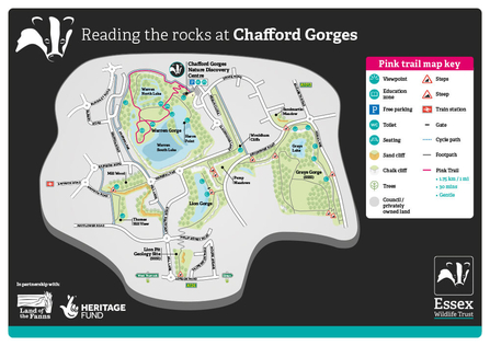
Pink trail
Easy (Warren Gorge only): 1.75km = 30 minutes
Suitable for prams and wheelchairs when dry.
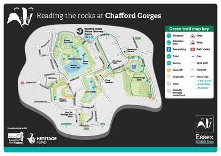
Green trail
Eastern parts of the reserve: 4km = 1hour 15 minutes
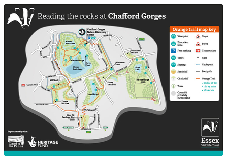
Orange trail
Western parts of the reserve: 6km = 1 hour 45 minutes
Blue trail
Most of the reserve: 7km = 2 hours
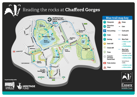
There is the option to extend the blue trail to cover Warren Gorge 8.5km = 2 hours 30 minutes or Wouldham Cliffs 7.5km = 2 hours 15 minutes.
The trails may be walked in reverse. The waymarked posts are laid out to guide the way at major path splits, however as the reserve is separated by roads and cycle paths, please refer to the trail direction descriptions below.
Pink trail

- Start from the Nature Discovery Centre at the decking overlooking Warren Gorge. Warren Gorge is the largest of the chalk pits that make up Chafford Gorges Nature Discovery Park. Warren Farm was situated here in the 18th century, and this is where the Gorge gets its name. Quarrying of the chalk accelerated from 1874 when Portland Cement began operating, finishing in the 1950’s. Essex Wildlife Trust gained control of Warren Gorge and most of Chafford Gorges Nature Discovery Park in 2005.
- Make your way towards the zigzag path from the Nature Discovery Centre (or follow the cycle path Northwest around the Nature Discovery Centre if the gate is closed). The post is situated alongside the map through the kissing gate on the right. Follow the zigzag path down to the bottom. If you take the path off to the left by the next post, it opens up to a good view of the South Lake and at night, is prime Daubenton’s bat hunting territory. (This path is a dead end.)
- Go straight on and then turn left at the junction towards ‘Goose Beach’. You should be able to see a lifebuoy holder and a bench at the turn. You will walk past calcareous grassland meadows, which are the most important habitat type on the nature reserve. Calcareous grassland is low in nutrients resulting in high biodiversity. Our management of the grassland attempts to prevent succession into woodland by reducing the nutrient content of the soil. Nutrients such as nitrogen naturally get fixed into the soil by bacteria, which is then balanced by other bacteria. Recently however, with the burning of fossil fuels, nitrogen content is increasing in all soils. Dog mess left behind also increases the nutrients and damages the grassland as the nutrients are not native to the habitat.
- Head past Goose Beach and stay on the path. Please do not feed the geese and other waterfowl white bread as this is bad for them and can make them unable to fly away from predators. On the left is a second open area normally full of waterfowl.
- Approach the crossroads (there is a willow dome in the making). Turn left, as it loops past here again later. You will pass a fenced off area which is the ‘education zone’ where children’s events and birthday parties take place.
- At the southern point of the path, you can see the cliff face clearly. This is a good spot to keep a look out for kingfishers. Look for a flash of blue and listen for a high-pitched call. Great crested grebes often hunt for fish here as well. Keep the water on your left-hand side here and you will see the next post on your left after about 300 metres.
- This post is by the culvert, which links the north and south lakes. The water will be flowing beneath your feet here. Travel up the ‘exit slope’ to find the next post.
- Another dead-end path will be on your right at the post. Often you can get a good view of a cormorant basking in the sun along here. You will pass through sections of the coppicing rota in place for Warren Gorge, and your view of the lake as you carry on up the exit slope is dependent on where in the cycle of coppicing we are.
- As you reach the top of the slope, you will see the last post and the map board. You can turn right along the cycle path to reach the Nature Discovery Centre again or follow the Orange trail if you feel like a longer walk from here.
Green trail

- Start at the Nature Discovery Centre. Walk out of the car park. Turn left along Drake road. Carry on past The Sand martin pub on your left-hand side. After the pub and the meadow you will see a sand cliff which is home to mining hymenopteran bees and wasps - look out for the small holes they create. Also, keep your eyes peeled for migratory sand martins which create larger holes in the cliff face. To your left you will see the sand martin meadow area. This meadow has the highest biodiversity levels per square meter in the entirety of Chafford Gorges Nature Discovery Park. Cross Devonshire Road at the island and you will see a pedestrian gate in front of you.
- Turn left once inside the gate. You are now walking through Grays Gorge (top shelf). Here you will see and pass several calcareous grassland areas and viewpoints. If you are here in May or June, you will be treated to a spectacular orchid display. You will pass a wooden Grays Gorge information board that will tell you more about the Sarsen stones here.
- You will find the third post to the right of the first path split. Stay right and you will come to the man orchid meadows. Continue through the meadows and you will notice a set of steps to your left. If you are here in May, head up them where you will be met by a sea of blue tufted vetch. With the base of the steps behind you, continue left through to the last meadow of the top shelf.
- The path will then open up to the large ‘End meadow’. On your immediate right you will find the next post, and the steps down to the bottom shelf.
- Once down the steps from End Meadow, take the left hand path. This can be muddy at times so be careful. You will pass a north and a south facing scallop into the woodland. This changes the microclimate and allows for greater floral diversity. You will then see more calcareous grassland - re-opened in 2015 as part of a scrapings project to restore the grassland which the invertebrates that make this area a SSSI need to survive. Pass the Chafford Gorges Nature Discovery Park ‘Lower shelf SSSI’ interpretation board.
- Turn right when you see the trail post to walk past one of the ephemeral pools on your right - home to aquatic invertebrates and newts. The bunds surrounding the pools act as hibernacula for reptiles and amphibians. Once past the bunds, carry on straight, past the bench under a beech tree and take a slight right and continue past the post following the railway sleepers in the ground past the lime kiln.
- Follow this path as it bends left at the end of the meadows past another ephemeral pool and bund, and Grays Lake will become apparent on your right-hand side. Continue along the path until you pass another scallop on the right and reach another set of meadows. Past the bench on your left, you will have the option to head left, back to the last post and loop back around the lake to this point. Or, continue straight on through the woodland before taking a left back to the post before last. The last option is to turn right, following the trail towards the next post and a wooden interpretation board.
- Scale the steps back to the top shelf.
- At the next post, turn left.
- As you reach a concreted section, you will be leaving Grays Gorge SSSI. Walk over the concrete and you will see the path turns right uphill. On your left is the tank farm (petrochemical storage) and a lake that is home to great crested newts and other aquatic species. Carry on until you see steps on your right down to the road.
- From here, carefully cross and take the cycle path in front of you. The path takes you all the way to Drake Road, which the Nature Discovery Centre is on. You will be walking parallel to Wouldham cliffs (on the Orange trail), and will pass evidence of permafrost in the rocks near the top of the cycle path. Once on Drake Road, turn left and you will see the car park on your right shortly.
Orange trail

- Start from the Nature Discovery Centre at the decking overlooking Warren Gorge. Warren Gorge is the largest of the chalk pits that make up Chafford Gorges Nature Discovery Park. Warren Farm was situated here in the 18th century, and this is where the Gorge gets its name. Quarrying of the chalk accelerated from 1874 when Portland Cement began operating, finishing in the 1950’s. Essex Wildlife Trust gained control of Warren Gorge and most of Chafford Gorges Nature Discovery Park in 2005.
- Make your way towards the zigzag path from the Nature Discovery Centre (or follow the cycle path Northwest around the Nature Discovery Centre if the gate is closed). The post is situated alongside the map through the kissing gate on the right. Follow the zigzag path down to the bottom. If you take the path off to the left by the next post, it opens up to a good view of the South Lake and at night, is prime Daubenton’s bat hunting territory. (This path is a dead end.)
- Go straight on and then turn left at the junction towards ‘Goose Beach’. You should be able to see a lifebuoy holder and a bench at the turn. You will walk past calcareous grassland meadows, which are the most important habitat type on the nature reserve. Calcareous grassland is low in nutrients resulting in high biodiversity. Our management of the grassland attempts to prevent succession into woodland by reducing the nutrient content of the soil. Nutrients such as nitrogen naturally get fixed into the soil by bacteria, which is then balanced by other bacteria. Recently however, with the burning of fossil fuels, nitrogen content is increasing in all soils. Dog mess left behind also increases the nutrients and damages the grassland as the nutrients are not native to the habitat.
- Head past Goose Beach and stay on the path. Please do not feed the geese and other waterfowl white bread as this is bad for them and can make them unable to fly away from predators. On the left is a second open area normally full of waterfowl.
- Approach the crossroads (there is a willow dome in the making). Turn left, as it loops past here again later. You will pass a fenced off area which is the ‘education zone’ where children’s events and birthday parties take place.
- At the southern point of the path, you can see the cliff face clearly. This is a good spot to keep a look out for kingfishers. Look for a flash of blue and listen for a high-pitched call. Great crested grebes often hunt for fish here as well. Keep the water on your left-hand side here and you will see the next post on your left after about 300 metres.
- This post is by the culvert, which links the north and south lakes. The water will be flowing beneath your feet here. Travel up the ‘exit slope’ to find the next post.
- Another dead-end path will be on your right at the post. Often you can get a good view of a cormorant basking in the sun along here. You will pass through sections of the coppicing rota in place for Warren Gorge, and your view of the lake as you carry on up the exit slope is dependent on where in the cycle of coppicing we are.
- Turn left instead of right at the cycle path and follow it for approx. ten minutes around the top of the Gorge (keep it on your left). You will pass a viewpoint over Warren Gorge from which you can see across to the Nature Discovery Centre. Turn left as you get to the crossroads and continue past Hatton and Hepburn Close. A playpark will be on your left, and on the opposite side of Rainbow Road is Mill Wood where you can see a Chafford Gorges Nature Discovery Park map board and the next post.
- You are now in Mill Wood - remnant ancient woodland that used to stretch all the way to the Thames before subsequent farming and quarrying.
- At the next post, turn right along the ride - an open linear path through the woods that allows light to reach the woodland floor and improve floristic diversity.
- You will be faced with steps in front of you and see the next post. Go down the steps to the meadow below, looking at the holes in the sand cliff to your left. These are made by mining solitary hymenopterans (bees and wasps), with larger holes created by nesting migratory sand martins. When at the bottom of the steps, you should be able to see a post on your left.
- This is the start of Thames Hill View. This hill was built from the spoils of the quarry. We have been widening the linear path and creating habitat piles to improve the area for reptiles and glow worms. The west slope is cut on a rotational basis to allow meadow wildflowers to flourish on the bank, and act as a biodiversity corridor for pollinators.
- Carry on along Thames Hill View until you reach the viewpoint. You can see Tilbury docks to the left, Proctor and Gamble ahead of you, and the QE2 bridge to the right. Follow the rope rail (erected by Thameside Scouts) down to the cycle path.
- 15. At the cycle path, turn left and follow it until you reach Mayflower road. Turn left again and go past three roundabouts. You should now be on Philip Sidney Road. This road wasn’t here before Chafford Hundred was built, and Lion Gorge on the left continued on the right which is now Lion Pit SSSI. On either side of the road is a section owned by the council before you reach Essex Wildlife Trust’s land, marked by green gates. Take the path to the right (south) down a zigzag slope to Lion Pit SSSI.
- 16. Lion Pit SSSI was a tramway cutting that enabled chalk to be carried to the banks of the Thames. When digging was taking place, fossilised remains of woolly rhino and straight tusked elephant were found, alongside many Neanderthal tools. The site also shows textbook quaternary boundaries.
- As you approach the southern side of the geological SSSI, you will see a bridge on London road. From here, you can either go up the steps and turn right twice to follow Mill Lane back to Philip Sidney road, or you can turn around and walk back up the zigzag path and across the road to Lion Gorge.
- Here, continue down the zigzag path to the next post at our green entrance gate. Lion Gorge is mostly looked after by Chafford Gorges Community Fishing Club, who lease the fishing rights.
- Take the left-hand fork at the next post to head down towards the lake itself, which is always very tranquil.
- Take the steps up. The palisade on your left is the route towards the tunnels that connect Lion and Warren Gorges, which are grilled off to allow bats to roost in them. Head towards the gap in the chalk.
- You will come to Devonshire Road. Turn left.
- Very soon, on your left you will see the next post at the base of the steps up to Wouldham cliffs. In the cliff on the left, you will find an example of a solution pipe where the chalk has been eroded and infilled by the younger Thanet sand. The more durable flints line the boundary.
- Turn right at the top of the steps and walk along the linear meadow. Halfway along you will find a viewing point over the tank farm and looking south over towards the Thames. Carry on along the meadow, past a gate on your left.
- Turn left at the end of the gate and you will be on Merlin Close. Turn right towards Drake Road and then left back to the Nature Discovery Centre.
Blue trail

- Start at the Nature Discovery Centre. Walk out of the car park. Turn left along Drake road. Carry on past The Sand martin pub on your left-hand side. After the pub and the meadow you will see a sand cliff which is home to mining hymenopteran bees and wasps - look out for the small holes they create. Also, keep your eyes peeled for migratory sand martins which create larger holes in the cliff face. To your left you will see the sand martin meadow area. This meadow has the highest biodiversity levels per square meter in the entirety of Chafford Gorges Nature Discovery Park. Cross Devonshire Road at the island and you will see a pedestrian gate in front of you.
- Turn left once inside the gate. You are now walking through Grays Gorge (top shelf). Here you will see and pass several calcareous grassland areas and viewpoints. If you are here in May or June, you will be treated to a spectacular orchid display. You will pass a wooden Grays Gorge information board that will tell you more about the Sarsen stones here.
- You will find the third post to the right of the first path split. Stay right and you will come to the man orchid meadows. Continue through the meadows and you will notice a set of steps to your left. If you are here in May, head up them where you will be met by a sea of blue tufted vetch. With the base of the steps behind you, continue left through to the last meadow of the top shelf.
- The path will then open up to the large ‘End meadow’. On your immediate right you will find the next post, and the steps down to the bottom shelf.
- Once down the steps from End Meadow, take the left hand path. This can be muddy at times so be careful. You will pass a north and a south facing scallop into the woodland. This changes the microclimate and allows for greater floral diversity. You will then see more calcareous grassland - re-opened in 2015 as part of a scrapings project to restore the grassland which the invertebrates that make this area a SSSI need to survive. Pass the Chafford Gorges Nature Discovery Park ‘Lower shelf SSSI’ interpretation board.
- Turn right when you see the trail post to walk past one of the ephemeral pools on your right - home to aquatic invertebrates and newts. The bunds surrounding the pools act as hibernacula for reptiles and amphibians. Once past the bunds, carry on straight, past the bench under a beech tree and take a slight right and continue past the post following the railway sleepers in the ground past the lime kiln.
- Follow this path as it bends left at the end of the meadows past another ephemeral pool and bund, and Grays Lake will become apparent on your right-hand side. Continue along the path until you pass another scallop on the right and reach another set of meadows. Past the bench on your left, you will have the option to head left, back to the last post and loop back around the lake to this point. Or, continue straight on through the woodland before taking a left back to the post before last. The last option is to turn right, following the trail towards the next post and a wooden interpretation board.
- Scale the steps back to the top shelf.
- At the next post, turn left.
- As you reach a concreted section, you will be leaving Grays Gorge SSSI. Walk over the concrete and you will see the path turns right uphill. On your left is the tank farm (petrochemical storage) and a lake that is home to great crested newts and other aquatic species. Carry on until you see steps on your right down to the road.
- Do not go down the steps but instead continue up and over the hill until you get to a kissing gate. Cross the road and turn left. On your right you will see chalk cliffs. In the chalk, you can see a horizontal line of flint resulting from erosion of the chalk, caused by changing sea levels. There is a 30-million-year gap between the chalk below the line and that above. Below the chalk cliffs are the pump meadows - you will pass a pumping station which prevents Lion Gorge Lake from flooding.
- Ignore the Orange trail post on your right and continue until you reach the entrance of Lion Gorge. The post is on the left of the green gate.
- Carry on into Lion Gorge and take the steps on the right, down to the lake. Lion Gorge is mostly looked after by Chafford Gorges Community Fishing Club, who lease the fishing rights. Do not head back up the steps but take the slope up to the left of the post if looking from the top of the steps.
- Continue straight on (slight right) and you will reach the southern end of Lion Gorge at our green gate.
- From here, walk up the council owned zigzag path to Philip Sidney Road. Cross over, and head down the other side on another zigzag path to Lion Pit SSSI and our green entrance gate.
- Lion Pit SSSI was a tramway cutting that enabled chalk to be carried to the banks of the River Thames. When digging was taking place, the fossilised remains of woolly rhino and straight tusked elephants were found, alongside many Neanderthal tools. The site also demonstrates textbook quaternary boundaries.
- As you approach the southern side of the geological SSSI you will see a bridge on London road. From here, go up the steps past the bus stop, turn right twice and follow Mill Lane back to the Philip Sidney Road roundabout (Lancaster road is ahead of you). Turn left onto Mayflower Road. Walk past Hatfield Road, Santiago Way and Norfolk Place and soon there will be a cycle path on your right. Take it.
- As you approach Thames Hill View, you should see a post and a rope rail on your right.
- At the top, you can see Tilbury docks to the left, Proctor and Gamble ahead of you, and the QE2 bridge to the right. Carry on north along Thames Hill View. This is a hill built from the spoils of quarrying. We have been widening the linear path and creating habitat piles to improve the area for reptiles and glow worms. The west slope is cut on a rotational basis to allow meadow wildflowers to flourish on the bank and act as a biodiversity corridor for pollinators.
- Turn left at the next post and follow the steps on your right up to Mill Wood - remnant ancient woodland that used to stretch all the way to the Thames before subsequent farming and quarrying.
- Go straight at the top of the steps, past the post and into the ride - a linear path through the ancient woodland that allows light to reach the woodland floor and improve floristic diversity.
- Turn left at the end of the ride by the next post.
- You will pass through the kissing gate and onto the pavement. Cross over the road to the playpark side. You have four options from here:
- Keep the playpark on your left to go along Warren and Clockhouse Lane, back to the Nature Discovery Centre.
- Keep the playpark on your left to go along Warren and Clockhouse Lane. After the roundabout at Lancaster Road, there will be an entrance to Wouldham cliffs to your right on the other side of the road. Enter and turn left along Wouldham Cliffs to walk along the linear meadow. Halfway along is a viewpoint looking over the tank farm and South across the Thames. Carry on along the meadow, past a gate on your left. Turn the left at the end of the gate and you will be on Merlin Close. Turn right towards Drake Road and then left back to the Nature Discovery Centre.
- Keep the playpark on your right and meet the cycle path. Where the cycle path turns right, take it and go past the viewpoint all the way until you get to the green gate. From here you can follow the Pink trail in reverse to get back to the Nature Discovery Centre.
- Keep the playpark on your right and meet the cycle path. Where the cycle path turns right, take it until you get to the green gate. Keep going along the cycle path and it will lead back to the Nature Discovery Centre and car park without going down Warren Gorge.
Interpretation boards

- Sand martin meadow
Pick up the Blue trail from point 1. Pick up the Green trail from point 1. - Rarer than rainforest
Pick up the Green trail from point 2. Pick up the Blue trail from point 2. - Urban oasis
Pick up the Green trail from point 3. Pick up the Blue trail from point 3 - Site of Special Scientific Interest
Pick up the Green trail from point 4. Pick up the Blue trail from point 4. - Magnificent meadows
Pick up the Green trail from point 4. Pick up the Blue trail from point 4. - Pit floors
Pick up the Green trail from point 10. Pick up the Blue trail from point 10. - Joining the dots
Pick up the Blue trail from point 11. - Pump meadows
Pick up the Blue trail from point 11. - Sea change
Pick up the Blue trail from point 11. - What’s the solution?
Pick up the Orange trail from point 22. - Sculpted by our industrial past
Pick up the Orange trail from point 18. Pick up the Blue trail from point 14. - Minerals & mega fauna
Pick up the Orange trail from point 16. Pick up the Blue trail from point 16. - Step into the steppe
Pick up the Orange trail from point 17. Pick up the Blue trail from point 17. - Chafford’s mammoth past
To pick up the Blue or Orange trails, head to London Road and see the ‘step into the steppe’ sign behind the bus stop. (Point 17). - Cementing a place in history
To pick up the Blue or Orange trails, head through the playpark and turn left onto Weymouth Drive as soon this becomes Philip Sidney Road. At this point, you can pick up the trails from point 15. - Ancient elm gate
To join the Orange and Blue trails from here, head down the hill and turn left at the roundabout to reach point 15. - Thames Hill View
Pick up the Orange trail from point 14. Pick up the Blue trail from point 19. - Meadows, mountains and veterans
Pick up the Orange trail from point 12. Pick up the Blue trail from point 20. - The butterflies and the bees
Pick up the Orange trail from point 12. - Chalk corridor
Pick up the Orange trail from point 23. Pick up the Blue trail from point 23b. - Walk along an ancient riverbed
Pick up the Orange trail from point 24. Pick up the Blue trail from point 23b. - Mammoth free zone
Pick up the Green trail from point 11. - Nature Discovery Centre
You can pick up all the trails from point 1 here. There are 4 trails to pick up that take you around the reserve. Choose from Pink, Green, Orange and Blue. - Warren Gorge car park map board
There are 4 trails to pick up that take you around the reserve. Choose from Pink, Green, Orange and Blue. - Warren Gorge map board
Pick up the Pink trail from point 2. Pick up the Orange trail from point 2. - Warren Gorge exit slope map board
Pick up the Pink trail from point 9. Pick up the Orange trail from point 9. Pick up the Blue trail from point 23(c). - Mill Wood map board
Pick up the Orange trail from point 10. Pick up the Blue trail from point 22. - Lion Gorge Map board
Pick up the Orange trail from point 21. Pick up the Blue trail from point 12. - Grays Gorge Sarsen stone meadow board
Pick up the Green trail from point 2. Pick up the Blue trail from point 2. - Grays Gorge man orchid meadow board
Pick up the Green trail from point 3. Pick up the Blue trail from point 3. - Grays Gorge lower shelf SSSI BOSS meadow board
Pick up the Green trail from point. Pick up the Blue trail from point 8 . - Grays Gorge lower shelf SSSI southern meadow board
Pick up the Green trail from point 5. Pick up the Blue trail from point 5.